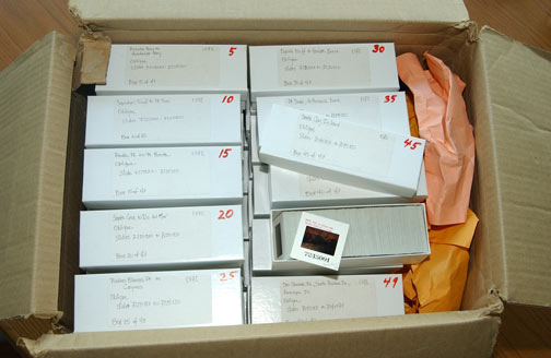
1972 slides in storage
In 1972 and 1979 the State Department of Boating and Waterways, under the direction of George Armstrong, carried out two statewide aerial surveys. The images that resulted have been stored in cardboard boxes, inaccessible to the public and, because of the lack of computerized tools, even difficult for the custodians to access.
These aerial surveys include the entire California coast, including the area around the Vandenberg AFB. The 1972 set includes the California Channel Islands and a short distance into Mexico.
Little is known about the original photography, e.g., the type of film used, and the slides are in deteriorating condition due to the fading of the color film dyes. The reddish cast is probably indicative of the film emulsion being a variety of Ektachrome or a similar film. Even the location of the original slides isn't known; the slides we've scanned were copies made in the 1970s. Some of the original notes describing the 1979 slides can be found here. Even less is known about the 1972 photographs.
1972 slides in storage
In November 1972 the California voters passed Proposition 20, the "Coastal Conservation Initiative". This lead to the passage in 1976 of the California Coastal Act, which made permanent the coastal protections that the California voters approved in 1972. The 1972 aerial survey is especially important because it represents the state of the coast at the time of the passage of Proposition 20. Any changes or new development in the coastal zone since 1972 occurred under the supervisory powers of the California Coastal Commission.
The goal of this project was to create a photographic record of the California coast that could be used to see how it changes over time. We envisioned this record starting with our 2002 photographs, but never imagined that we would be able to extend the dataset back in time a full 30 years to 1972. Although the resolution of these older photographs isn't as good as the 2002 and later sets, and the colors have deteriorated, they need to be viewed in the context that they may be some of the only surviving photographs that document the entire California coast from that era. They are immensely valuable.
|
|
|
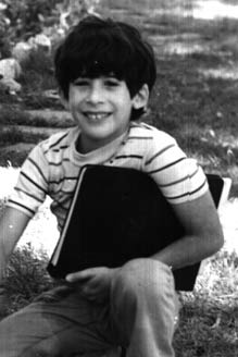
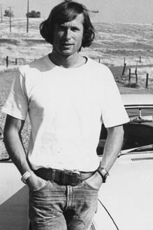
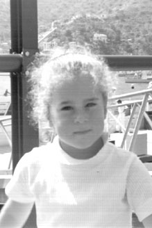
| Kenneth Adelman, circa 1972 | Gary Griggs, circa 1972 | Gabrielle Adelman, circa 1972 |
The first step is always the largest one. In order to preserve the imagery, a project was undertaken at the Institute of Marine Sciences at the University of California, Santa Cruz, under the direction of Professor Gary Griggs, to scan the images. A Nikon Coolscan 4000 and a Nikon SF-20 feeder were used to scan them at 2000 lines per inch, 16-bit color depth, and the output was saved in an uncompressed TIFF format. Portions of the 1979 slides were scanned on a Nikon Coolscan 5000 with a Nikon SF-21 feeder. The dyes used in the original film base have both faded and changed color in the 30 years since they were taken. It was expected that multiple attempts might be made to restore the original colors, and we wanted to be sure that the original uncorrected images were available in electronic form; therefore, no color correction was performed in the scanner. For unknown reasons, the 1972 slides appear to be in significantly better condition than the 1979 slides. The 1972 imagery consists of 5833 slides and the 1979 imagery consists of 8006 slides. Each of the original TIFF images is 32.6MB; the 1972 and 1979 sets comprises almost 451GB of data.
Although the slides of the California Channel Islands have been scanned for preservation, they are not presented on this site.
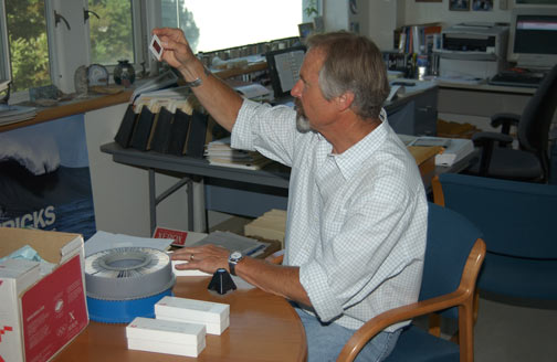
Professor Gary Griggs examining a slide
The color restoration was performed using an Apple PowerMac G4 running Photoshop 7 with the Applied Science Fiction Digital ROC Professional plug-in (Set for Brightness 25, Black Clip .5%, White Clip .5%, Digital Camera input), followed by an Auto Color Balance in Photoshop. The Digital ROC plug-in is designed to restore the original colors from time-faded color films. The parameters used in the restoration were chosen based on a visual sampling of a small number of slides, and then consistently used on the entire dataset. It is likely that a better restoration could be performed on a slide-by-slide basis, but the labor required makes this effort prohibitive.
Once the color restoration was completed, Photoshop was used in a fashion similar to that used on the contemporary photographs to produce the downsized images used on this web site.
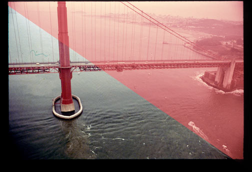
1979 slide showing the color balance before and after restoration
The 1972 and 1979 slides have very little accompanying documentation. Unlike the 2002 and later photographs that we have taken ourselves, the exact position of the aircraft for each of these photographs is unknown. Presenting them on the web was an interesting challenge. The slides, as found, were sorted Northwest to Southeast (with a few exceptions as noted). We have visually identified the location of approximately 775 of the over 5800 slides taken in 1972 and 921 of the 8000 slides taken in 1979 by comparing them to the 2002 photographs and have calculated a position which we presume was close to the location of the aircraft. For the rest of the slides, we have automatically interpolated the position of the aircraft for the purposes of presentation (interpolated positions are shown in gray). In general, we expect these presumptive aircraft positions to be accurate to within a mile, and many of them accurate to a quarter mile or less. It is important to note that these positions are only roughly calculated for the purposes of presentation on this web site and are not intended to reflect what might have been the actual position of the aircraft. If you find errors in the position information, please call it to our attention. It is important that you identify the Image Number of the mis-indexed 1972 or 1979 photograph along with the Image Number of the closest 2002 photograph.
Because we do not have 2002 photographs of Tijuana or of the Vandenberg Restricted Areas, the position information in these vicinities was determined by comparison to satellite photographs from Google Earth and is linearly interpolated between identified points.
In a number of areas, usually around river mouths or sloughs, the 1972 photographer deviated from our style and flew inland, shooting a number of photographs up rivers or from the land looking back at the ocean. We have no good source of position information for these photographs, so by default we suppress them from the normal website sequence.
The underlying web engines did not require much work to accommodate the earlier photographs. A new format of page was added, called "Time Comparison", that permits the viewer to see different time periods side by side.
We are hopeful that other image datasets suitable for display as part of the California Coastal Records Project will be found and added to this site.